|
The National Ground-Water Monitoring Network (NGWMN) is a compilation of selected wells monitoring groundwater aquifers all around the nation. The NGWMN Data Portal brings groundwater data together in one place to provide users with current and reliable information for the planning, management, and development of groundwater resources. About the Network
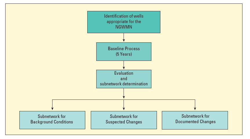
BackgroundThe NGWMN network was sponsored by the Advisory Committee on Water Information's (ACWI) Subcommittee on Ground Water (SOGW) and was established in 2009 with a pilot network. ACWI and its subcommittees were deactivated in 2019, but the NGWMN still exists and is maintained by the USGS. The goal of the National Ground-Water Monitoring Network (NGWMN) is to provide information needed for planning, management, and development of groundwater supplies to meet current and future water needs and ecosystem requirements. This will be accomplished by aggregating suitable groundwater data from local, State, and Federal organizations. A consensus-based��framework document was developed to provide guidance to ensure that the data are comparable and can be included in a nationally consistent network. The framework design focuses on providing information needed to assess the quantity of groundwater reserves as constrained by quality. The scale of the network focuses on Principal and Major Aquifers of the United States. Network DesignThe network is composed of selected wells from existing Federal, multi-state, State, Tribal, and local groundwater monitoring networks. The focus of the NGWMN is the water levels and water quality of the Principal and Major Aquifers of the United States. Well classification subnetworks and monitoring categories are defined in the��framework document �and are briefly described here: Well Classification Subnetworks:Wells in the NGWMN will be designated as being in one of three subnetworks. These are 1) the Background subnetwork, 2) the Suspected Changes subnetwork, and 3) the Documented Changes subnetwork. Background subnetwork: Monitoring points that provide data from aquifers or parts of aquifers with no (or minimal) anthropogenic effects. These are from areas that have been minimally affected by human activities and are expected to remain so. Suspected Changes subnetwork: Monitoring points that provide data from aquifers or parts of aquifers that may have been affected by man's activity, but that is not documented or conclusive. These wells may also be in areas where changes are anticipated. These may be areas with withdrawals are occurring or where land-use has changed, but the effect has not yet been clearly identified. Documented Changes subnetwork: Monitoring points that provide data from aquifers that have documented anthropogenic effects. The aquifers may: 1) be known to be heavily pumped 2) have experienced substantial recharge-altering land-use changes 3) have managed groundwater resources 4) are known to have degraded water quality or declining water levels. Baseline Process:The baseline process is required of all wells to provide or identify an initial monitoring record that is used to place the well into one of the above subnetworks. Five years of monitoring is generally considered adequate to establish these conditions. For existing wells, past data may be used to categorize wells into one of the subnetworks.
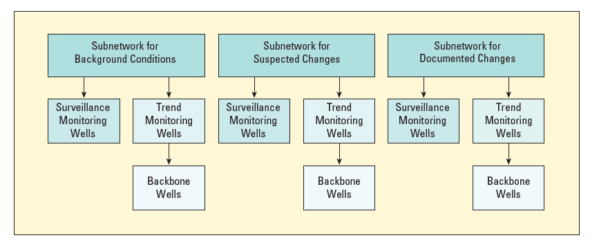
Monitoring Categories:Wells within each subnetwork (Background, Suspected Changes, or Documented Changes) will be assigned to a monitoring category depending on the purpose of the monitoring at the well. These categories, and conditions at the wells, will be used to determine suggested monitoring frequencies. Trend: Trend wells are generally monitored to determine changes over time. The frequency of monitoring depends on the hydrologic conditions of the aquifer and can range from daily data to annual measurements. A subset of the trend monitoring wells will be designated as the "backbone" wells of the NGWMN. Surveillance: Surveillance monitoring would be used in conjunction with Trend monitoring to periodically report on the overall water-level and water-quality conditions, or status, of the Nation's groundwater resources. NGWMN Surveillance monitoring can be thought of as a periodic "census" of groundwater level and quality. An overall snapshot of groundwater conditions in an aquifer is obtained with Surveillance monitoring. The frequency of Surveillance monitoring generally is much less than Trend monitoring. Special Studies: Special studies monitoring is a secondary aspect of the NGWMN. This monitoring is not required and is only provided as an option. Special studies monitoring would be most often associated with the Suspected or Documented Changes Subnetworks and would be used to evaluate the status of ground-water resources at risk, or potential risk, from depletion or impairment. The monitoring frequency would vary, depending on the study. Categorizing wells as special studies acts as a flag to indicate that additional information might be available because wells are measured or sampled for a special purpose regionally or nationally (for example, wells measured to observe the effects of hydraulic fracturing).
Network StatusA pilot phase that started in 2009 initially populated the network with data from 5 pilot networks. Following the pilot phase, additional USGS water-level monitoring wells that met the network criteria were added to the NGWMN for some states. In 2015, the Network received funding and began implementation. The Data Portal
The Data PortalThe NGWMN Data Portal is the access point for information about the wells in this network and for their related lithology (geology), construction, water-level and water-quality data. To access the portal�click here. Original data are retrieved from each data provider by the portal. Data from each provider is refreshed nightly to create a cached data set to allow queries to the data to be faster. These data are then transformed into a consistent format to serve out to the NGWMN Data Portal.� Queries can be made on network type (Water Level or Water Quality), well classification, and monitoring category. Sites can also be queried based on Principal Aquifer, type of data available, contributing agency, and state/county. Web ServicesWeb service requests may be submitted to obtain data directly and to bypass the NGWMN map interface. Currently only basic site information and water levels are available through web service requests. For full site information, lithology, construction information or water quality data visit the NGWMN Data Portal. For more information on the�NGWMN Web Services, see the�Web Services Guide. PublicationsBooth, N.L., Brodaric, B., Lucido, J.M., Kuo, I.-L., Boisvert, E., and Cunningham, W.L., 2011, Development of an Interoperable Groundwater Data Exchange Network between the United States and Canada, in GeoHydro 2011 Conference Proceedings Paper. URL:https://acwi.gov/sogw/pubs/tr/pilot_results/Booth_etal_GeoHydro2011.pdf Blodgett, D., Read, E., Lucido, J., Slawecki, T., and Young, D., 2016, An Analysis of Water Data Systems to Inform the Open Water Data Initiative: JAWRA Journal of the American Water Resources Association, v. 52, no. 4, p. 845-858. DOI:10.1111/1752-1688.12417 Larsen, S., Hamilton, S., Lucido, J., Garner, B., and Young, D., 2016, Supporting Diverse Data Providers in the Open Water Data Initiative: Communicating Water Data Quality and Fitness of Use: JAWRA Journal of the American Water Resources Association, v. 52, no. 4, p. 859-872. DOI:10.1111/1752-1688.12406 Blodgett, D., Lucido, J., and Kreft, J., 2015, Progress on water data integration and distribution: a summary of select U.S. Geological Survey data systems: Journal of Hydroinformatics, v. 18, no. 2, p. 226-237. DOI:10.2166/hydro.2015.067 Brodaric, B., Booth, N., Boisvert, E., and Lucido, J., 2015, Groundwater data network interoperability: Journal of Hydroinformatics, v. 18, no. 2, p. 210-225. DOI:10.2166/hydro.2015.242 Data Providers
The�National Ground-Water Monitoring Network (NGWMN)�is a compilation of selected groundwater monitoring wells from Federal, State, and local groundwater monitoring networks across the nation. The following agencies are currently contributing to the NGWMN. The agencies listed below are currently providing data to the NGWMN.� Alaska Department of Natural Resources Arizona Department of Water Resources Water Replenishment District of Southern California Colorado Department of Water Resources Florida Department of Environmental Protection Indiana Geological and Water Survey� Iowa Department of Natural Resources Minnesota Department of Natural Resources Minnesota Pollution Control Agency Mississippi Department of Environmental Quality Mojave Water Agency, California Montana Bureau of Mines and Geology Nebraska, Conservation and Survey Division Nebraska Department of Environment and Energy New Hampshire Geological Survey New Mexico Institute of Mining and Technology North Carolina Department of Environmental Quality Oklahoma Water Resources Board Oregon Water Resources Department South Carolina Department of Environmental Services Suwanee River Water Management District-Florida St. Johns River Water Management District-Florida Washington State Department of Ecology Wyoming Department of Environmental Quality Pending Data ProvidersThe following agencies are in the process of becoming a data provider to the NGWMN: Michigan Department of Environment, Great Lakes, and Energy USGS Cooperative Match Funds Projects Data ProvidersThe following agencies are NGWMN data providers through USGS Cooperative Matching Funds Monitoring programs with their local USGS Water Science Center. Information about data collection and data management procedures for these agencies are presented under the USGS Data Provider Page.� Specifics of past projects with these agencies are also shown on the� USGS Data Provider Page. Maryland Geological Survey Massachusetts Department of Conservation and Recreation Massachusetts: Cape Cod Commission Missouri Department of Natural Resources New Jersey Department of Environmental Protection Ohio Department of Natural Resources Wisconsin Geologic and Natural History Survey Get Involved
The�NGWMN�is actively seeking data providers for the Network. Data providers work with the USGS to set up connections between their databases and the NGWMN Data Portal to pass data to the Network as needed. The data providers also work with the USGS to select and classify wells for the Network. Information on a funding opportunity available to assist state or local water-resource agencies in becoming data providers is available�here. � Resources
Resources for New Data Providers:Information about USGS cooperative agreements to fund data providers is available�here. The National Ground-Water Monitoring Network focuses on Principal Aquifers. Principal Aquifers are defined by the USGS in the Ground Water Atlas. Principal Aquifers of the United States Map of the Principal Aquifers of the United States GIS Resources:Shapefiles of the 'Principal Aquifers of the United States' and the 'Aquifers of Alluvial and Glacial Origin' are available here. A shapefile of the sites in the NGWMN as of August 16, 2024 is available here. GIS layers in multiple formats of sites and the most-recent water level percentiles can be found on the Geoserver page. New Data Provider Tip Sheets:Tip Sheet on Well Selection Criteria for Water Levels� Tip Sheet on Well Selection Criteria for Water Quality Tip Sheet on Defining the "Subnetwork" Tip Sheet on Defining Monitoring Categories� Tip Sheet on Populating the Monitoring Location Registry Tip Sheet on Minimum Data Requirements for Candidate Sites Tip Sheet on Web Service Development Wyoming DEQ Tip Sheet on creating ARCGIS server web services Tip Sheet on Standard Elements for Water-Quality web services General Tip Sheets:Monitoring Location Registry Documentation Monitoring Location Registry Field Definitions Creating Shapefiles of NGWMN sites Viewing Water-Level Statistics in the NGWMN Data Portal Other Resources:A spreadsheet showing the suggested density of water-level and water-quality sites by state and Principal aquifer is available�here. The NGWMN Well Registry Management System can be accessed�here. Program Announcement
2025 Funding Opportunity The USGS National Groundwater Monitoring Network (NGWMN) Cooperative Funding Opportunity for 2025 is now closed. However, information has been retained below for reference. The 2026 Progran Announcement will be open in the Fall of 2025. � The funding will be for a 2-year period beginning in July 2025. Cooperative agreements will provide support for both new and existing data providers in the NGWMN. The USGS will fund new data providers to select and classify sites within existing monitoring programs, to set up web services that will link the data to the NGWMN Portal, and to produce a report describing this process. Existing data providers can apply for funding to maintain web services and keep site information current. Data providers may also apply for funding to collect data to improve site information, to maintain wells, to drill new or replacement Network wells, or purchase continuous water-level monitoring equipment for the NGWMN.� Interested agencies may apply online at Grants.gov under funding opportunity number G25AS00001. More information about the funding opportunity is available on the NGWMN Portal under the Program Announcement tab. Applications must be submitted no later than 4:00 p.m., ET, on January 16, 2025. Applications will only be accepted electronically through Grants.gov; paper copies will not be accepted. The Program Announcement contains the requirements and other guidance for submitting proposals. � If you would like more information on the funding opportunities, a PDF file of the most recent information session is available here and a recording of the December 2024 information session can be found here. If you have questions about the National Ground-Water Monitoring Network Program, please contact:� Rod Caldwell� caldwell@usgs.gov� �Resources for Proposals
State Waterlevel Download
State Water Level Data:Downloads of water levels from all sites within an entire state are available in .csv format using the links below. Data in these files represent all water level data within the NGWMN for all time within a single state. Users will need to download site information, water quality, and well log information separately. Select a state or territory for full download:
Territories
|