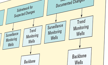
National Ground-Water Monitoring Network
The National Ground-Water Monitoring Network (NGWMN) activities are conducted under the authority of the Omnibus Public Land Management Act of 2009 (Secure Water Act), reauthorized in 2024.ĀThis Network is a product of theĀSubcommitteeĀon Ground WaterĀof the Federal Advisory Committee on Water Information (ACWI). TheĀNGWMN is a compilation of selected groundwater monitoring wells from Federal, State, andĀlocal groundwater monitoring networks across the nation. The design for the National Ground-Water Monitoring Network is presented in the document 'A National Framework for Ground-Water Monitoring in the United States'.
The NGWMN Data PortalĀprovides access to groundwater data from multiple, dispersedĀdatabases in a web-based mapping application. The portal contains current and historical dataĀincluding water levels, water quality, lithology, and well construction. The NGWMN is currentlyĀin the process of adding new data providers to the Network. Agencies or organizations collectingĀgroundwater data canĀfind out more about becoming a data provider for the Network.
Funding to support data providers to the National Ground-Water Monitoring Network isĀprovided throughĀUSGS Cooperative Agreements. Agencies can also findĀinformation about the status of theĀUSGS cooperative agreements.
New (1/16/2025): The USGS National Groundwater Monitoring Network (NGWMN) Cooperative Funding Opportunity for 2025 is now closed. The 2026 Funding Opportunity will be open in the Fall of 2025.
If you have questions about the National Ground-Water Monitoring Network Program, please contact:Ā
Rod CaldwellĀ
caldwell@usgs.govĀ
x | water-level wells |
|---|---|
x | water-quality wells |
| 10 | subnetworks |
x | contributing agencies |
x | administrative units |
x | principal aquifers |